Page contents...
Discover


- The Peak District was the first of Britain’s 15 national parks and was designated on 17th April, 1951.
- It covers 555 sq miles (1,438km) in the heart of England (that’s about the size of Greater London).
- The Peak District reaches into five counties: Derbyshire, Cheshire, Staffordshire, Yorkshire and Greater Manchester.
- It is the most accessible national park – close to the cities of Manchester, Sheffield, Nottingham and Derby.
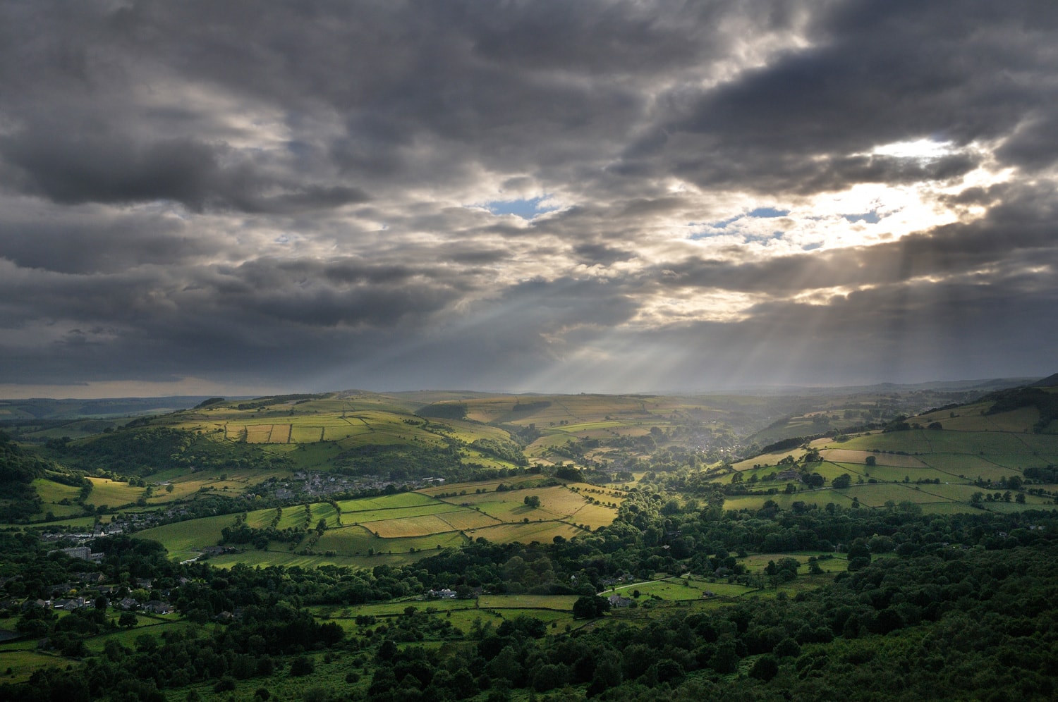
- The Peak District is made up of impressive gritstone edges (Dark Peak), steep limestone dales (White Peak) and rolling hills and farmland (South West Peak).
- The highest point is Kinder Scout at 2,086ft (636 metres).
- The Peak District welcomes more than 13 million people each year.
- An estimated 20 million people live within an hour’s travel time of the Peak District.
- Unlike many of the world’s National Parks, which are wilderness areas, the Peak District is a true ‘living landscape’, home to 38,000 people (an IUCN ‘Category 5’ National Park).

Explore


- Visitors come to enjoy walking, climbing, cycling, mountain biking, caving, angling, nature-watching, photography, gliding, visiting historic houses, country pubs and tearooms.
- The nationally-renowned Pennine Way begins in the Peak District (in the village of Edale) and stretches 268 miles (431km) all the way to Scotland.
- The National Park has 202 sq miles of open access land – open to walkers without having to stay on paths – and 1,600 miles of public rights of way (footpaths, bridleways and tracks).
- The Peak District National Park Authority owns and manages 34 miles of traffic-free trails, mostly along former rail routes.
- Following the coronavirus lockdown, the numbers of those using some of our traffic-free trails to exercise doubled to almost 4,000 a day (nearly 230,000 visits over a three month period).
- The Trans-Pennine Trail through the Peak District is part of the E8 European Walking Route, connecting the National Park to the Turkish border – a walk of 2,500 miles!
- The introduction of new rights for access in 2004 doubled the amount of moor and heathland open to the public – from 240 to almost 500 sq km.
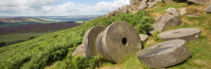
Millstones – our logo
- The millstone is the emblem of the Peak District National Park.
- It features in our boundary markers (several feet high) on key gateway routes into the National Park and in our logo.
- Their current basic form can be traced to before the Norman Conquest (1066). Corn mills are recorded in the Domesday Book of 1068.
- Quarrying for grit stone was first recorded in the area in the 12th and 13th centuries, though archaeological evidence suggests that mill stone production began during the Roman period.
- Extraction continued into the 19th century, with stone used for a variety of purposes including grinding corn, sharpening tools in industrial centres such as Sheffield and crushing timber for wood pulp as far away as Scandanavia.
- The millstone has changed over the centuries. A mushroom-shaped conical stone is an earlier shape that appears to be peculiar to the Peak District and may be medieval in origin. The more familiar wheel-like cylinder shape was produced in the 18th and 19th centuries and these millstones were used to grind grain such as oats, barley and rye.
- At Millstone Edge, near Hathersage, you can see the remains of old millstones abandoned after cheaper imports became available. The stones were used by the Sheffield cutlery industry, and also to sharpen steel wire into needles and pins.
History / cultural heritage

- Millions of years ago the Peak District was a tropical lagoon. The fossils of tiny sea creatures can be seen today, even at the highest peaks of the National Park.
- The Peak District was first farmed for sheep, cattle and crops 6,000 years ago. You can still see traces of fields and terraces cultivated in Roman times. By the end of the 20th century there were around half-a-million sheep, cattle and pigs in the Peak District.
- The name ‘Peak’ does not in fact relate to the region’s uplands, but is thought to derive from the Pecsaetan, an Anglo-Saxon tribe which settled in the area.
- The lead for white paint in Vermeer’s painting of Girl with a Pearl Earring came from the Peak District.
- Peveril Castle in Castleton is one of England’s earliest Norman fortresses. The stone keep was built by Henry II in 1176 and is now managed by English Heritage.
- Thousands of years of human influence can be seen throughout the National Park – in walls and field patterns, buildings, lanes, villages and former railways as well as prehistoric features such as burial mounds and stone circles.
- London’s landmark Nelson’s Column wasn’t the first memorial to the Battle of Trafalgar. In 1810 Peak District residents erected an impressive obelisk on Birchen Edge near Baslow. Three massive rocks close by - said to resemble ships’ prows - are inscribed with the names Victory, Defiant and Soverin.
- Sir Richard Arkwright – one of the most important figures in the Industrial Revolution – built an unusual home in the style of a castle at Cressbrook. From here you can walk along the side of the river to the wonderfully named Water-cum-Jolly Dale.
Traditions / folklore

- The annual Garland Day – or Oak Apple Day – takes place in Castleton on 29th May. A Garland Kind and Queen are paraded through the village on horseback wearing garlands of flowers. The King’s heavy garland is hoisted to the top of the church tower. The custom may commemorate the Restoration of Charles II.
- The Peak District is famous for the ancient tradition of well dressing. The world’s earliest recorded example of the art was at Tissington in 1349. More than 70 Peak District villages still take part in well dressings, which started as thanksgivings for pure water. They involve decorating wells with intricate mosaic pictures made from natural materials such as berries, seeds and petals.
Wildlife / nature


- The Peak District has a broad wildlife diversity, from the flower-rich limestone dales of the White Peak to the gritstone Dark Peak with its internationally important peat bogs and birdlife and the South West Peak with its mosaic of habitats.
- Nature highlights include:
- Mountain hares; the only UK population outside the Scottish highlands
- Red deer; rutting can be witnessed at various locations within the Peak District.
- Ring ouzel ‘mountain blackbird’; our gritstone edges hold a number of territories of this threatened summer migrant, which are protected through community partnerships.
- Water voles; the fastest declining UK mammal, ‘Ratty’ of Wind in the Willows fame can even be seen close to local towns and villages.
- Orchids; several species including the scarce frog orchid bloom in the White Peak dales and along former railway cuttings.
- Birds of prey; a number of species are now recovering in numbers through local initiatives, with sightings of peregrine, goshawk, short-eared owl and merlin possible. Buzzards, kestrels and ravens can be seen in many areas.
- Life in miniature is a treat to be discovered on peat bogs amongst the uplands, with round-leaved sundew and cotton grass highlights amongst the myriad sphagnum mosses.
Conservation and climate
- Three-quarters of the world’s heather moorland is in the UK – a large proportion in the Peak District National Park. It is of global ecological and conservation importance, supporting rare and endangered plants and animals.
- Peak District peat bogs are among the most important wildlife habitats in the world, home to many birds, thousands of rare insect species and a wealth of unusual plants. More than 94% of the UK’s peat bogs have been damaged or destroyed – they are at greater risk than tropical rainforest.
- Peak District blanket peat bogs act as a ‘carbon reservoir’ that locks in CO² - it’s almost as effective at combating global warming as the tropical rainforests.
What is the Peak District famous for?

- Blue John stone, which is found in Blue John and Treak Cliff caverns in Castleton and is made into jewellery and ornaments.
- Caves – Castleton. Blue John Cavern is famous for stalagmites and stalactites. The tallest cave in the Peak District is Titan Shaft in Castleton which, at 464ft (141.5 metres), is taller than the London Eye.
- The Peak District National Park hosts the starting point at the southern end of the Pennine Way, Britain’s oldest long-distance national walking trail, at Edale. Completed in 1965, it stretches 268 miles from the Nag’s Head pub in Edale to the Border Hotel, Kirk Yetholm, Scotland.
Film and Literature
- The Dark and White Peaks form the backdrop to murder and mystery in crime novelist Stephen Booth’s worldwide best-selling novels.
- The area has inspired writers for generations, from Jane Austen and Charlotte Bronte to William Wordsworth, Sir Arthur Conan Doyle and current writer Berlie Doherty.
- Charlotte Bronte stayed at North Lees Hall, Hathersage, in 1845 as guest of the Eyre family. North Lees appears in the novel Jane Eyre as Thornfield.
- Jane Austen based her novel Pride and Prejudice in Bakewell and Chatsworth. Chatsworth House was her inspiration for Mr Darcy’s magnificent Pemberley.
- A TV series of Pride and Prejudice – featuring Colin Firth as dashing Mr Darcy – was filmed in the Peak District in 1995 and cameras returned for a feature film, starring Keira Knightley, in 2005.
- In 1943, the RAF’s 617 squadron trained over Derwent and Howden reservoirs as they prepared to unleash Barnes Wallace’s bouncing bomb on Germany’s Ruhr Valley dams. In 1954 the bombers returned – along with leading actors Michael Redgrave and Richard Todd - in classic film The Dam Busters.
Rivers and Reservoirs


- Peak District reservoirs supply surrounding towns and cities with 450 million litres of water each day. Each year, that’s equivalent to a shower for the world’s entire population.
- Several rivers flow through the Peak District, the longest being the River Derwent. Others include the Dove, Wye, Manifold, Dane, and Etherow. The rivers support an amazing diversity of wildlife.
- Peak District rivers are renowned for their quality. The 17th Century author Charles Cotton described the River Lathkill as “the purest and most transparent stream I ever yet saw, either home or abroad”.
- The Peak District has some of the purest natural mineral water in the world, and is famous for brands including Buxton and Ashbourne.
- The water is naturally filtered during its long journey through hundreds of metres of porous rock. The water that emerges today from some sources fell as rain up to 5,000 years ago.
- In the late 18th Century, the National Park’s rivers supported the industrial revolution by providing power for the world’s first factories - including cotton mills at Calver, Cressbrook, Litton and Lumford.
- From the Victorian period, the Peak District was seen as a source of a fresh, clean water for the growing urban conurbations of Sheffield, Manchester, Nottingham, Derby and Leicester.
- There are three main reservoirs in the National Park – Derwent, Howden and Ladybower. Howden and Derwent dams were built between 1901 and 1916 of huge millstone grit blocks quarried from Grindleford and transported on a specially built railway line. They are finished with Victorian gothic architectural embellishments including towers, crenulations, arched windows and buttresses.
- The dams were built by hundreds of skilled workers who were housed in a specially built village called ‘Tin Town’, of which some traces can still be seen. Ladybower dam was built between 1935 and 1945. Today, the reservoirs are a focus for recreation and conservation interest, as well as continuing to supply the surrounding the towns and cities with clean water.