
Bleaklow - B29 bomber crash site
Due to the exposed nature of the crash site location and distance from parking areas, please be aware that weather conditions can change dramatically, even in summer. Read more below to keep your visit safe.
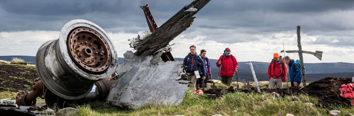
About the Bleaklow Bomber crash site
The B29 ‘Bleaklow Bomber’ crash site features the remains of a U.S. air force Superfortress aircraft, which crashed in November 1948 during a routine domestic flight between bases within the UK. It is at a remote location on the moorland plateau of the Snake Summit and is a sensitive environmental site, which requires responsible visiting. Sections of the route are unsurfaced and may be wet or boggy following periods of rain.
Found at least 2 miles (3.2 kilometres) or approximately an hour’s walk from the nearest parking opportunities, trips to the crash site should only be attempted if you are fully prepared, have planned your route and understand the fitness levels required to walk to the site and back again. Due to the nature of the area, there is limited signage and waymarking. Access should not be attempted outside of daylight hours.
The site remains at risk from damage and degradation due to high numbers of visitors so please consider this ahead of your trip.
The route to the crash site is not suitable for young children and there are no facilities at all at the location or along the route.
The aircraft ruins themselves include an engine turbine and a portion of the body of the plane. This remains a place of memorial where several airmen lost their lives and under no circumstances should any items be displaced or and taken away from the crash site.
Visitors are also asked not to take additional structures or mementos to the site as these can degrade, be carried away during bad weather and create litter or a risk to livestock and wildlife.
Please be aware that if you get into difficulty at this location, an emergency response may require a number of different services, including Mountain Rescue volunteers, and will take much longer than normal. Remember this could impact not only you or your party, but also those involved in any required rescue or extraction from the site.
Facilities
parking icon Parking
Please do not park anywhere on double yellow lines along the A57 'Snake Pass' which is unlawful.
Designated parking with access to the Pennine Way is available at Woodhead and Torside, along with 'Higher Shelf Stones' and at Snake Woodlands.
There are currently no facilities for EV vehicles. Please be aware that some sections of the route to the crash site may be unmarked and unsurfaced.
cafe icon toilet icon Café and toilets
There are no toilets or refreshment facilities at either the parking areas or the crash site itself.
picnic icon no bbq icons Picnics, no BBQs
You can enjoy a picnic in the open landscape or with your vehicle, but please take home what you bring. There are no public bins provided on the open plateau. BBQs or fires of any sort are not permitted anywhere in the parking area, along the route or at the crash site itself. If you believe you have seen a wild fire, please call 999 immediately and ask for the fire service.
Dog icon Visiting with your dog
Dogs are allowed at certain times of year (generally between September and February) but please keep them on a lead at all times for the safety and respect of other visitors. In particular, birds that nest on the ground are at particular risk from uncontrolled dogs during spring and summer. Adjacent fields may contain livestock where extra care should be taken. Please take all dog mess home.
Bus services
Some seasonal bus services may be available along the A57 but should not be relied upon.
Directions
The Bleaklow Bomber crash site is in the Dark Peak area of the Peak District National Park along the A57 between Manchester and the village of Bamford near Ladybower reservoir.
Please do not rely on smartphone apps or mapping software requiring mobile device reception to plan your route.
Parking area for Pennine Way and access to the crash site
Torside:
- Grid reference: SK 0680 9831
- Map / sat nav
- What3Words: ///gates.situates.clouding