Longshaw

Discover old highways and a ducal fishpond on Longshaw’s moorland estate. Livestock grazing.
Access for All and Many
Distance: 360 m and 160 m to the fishpond, 660 m and 1.3 km to the road
Nearest Facilities: Longshaw Estate Visitor Centre
Directions
Access for All and Many
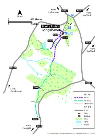
- From the front of the visitor centre, take the path alongside the meadow.
- After a gate, bear right alongside rhodendrons and the sunken wall of a ha-ha, which keeps livestock out.
- The path becomes more uneven as it drops down to the fishpond.
Or
Access for All and Many
- Pass through a second gate after the gate by the meadow.
- Continue along the level track to the stone gateposts and sculpture at the wood.
- The path becomes more uneven as it continues to the road.
Alternatives
Follow the accessible route from the car park past the ice-house to the rear of the visitor centre.
Longshaw Route Map (338KB) ![]()
Getting there
Start at Longshaw Estate Car Park, off the A6187, west of Sheffield.
Ordnance Survey grid reference: SK 2668 8009
Postcode: S11 7TY
Do you know?
- The former shooting estate of the Duke of Rutland was purchased by the people of Sheffield and donated to the National Trust in 1931.
- The Sheffield to Buxton road used to run through the meadows in front of the lodge. It was altered to its present course, in 1840, to be less visible from the lodge.
- In autumn, there are over 1,000 types of fungi found in the wood pastures.


